Drone technology has fundamentally transformed roof surveying in the UK, turning what was once a risky, time-consuming process involving ladders, scaffolding, and surveyors working at height into a safe, efficient aerial inspection delivering unprecedented detail. My Roof Surveyor UK was among the early adopters of professional drone survey technology, and after conducting over 1,500 drone-based roof inspections, we've witnessed firsthand how this technology benefits property owners, surveyors, and the quality of roof assessments.
This comprehensive guide explains how drone roof surveys work, their advantages over traditional methods, what property owners should expect, and how this technology is reshaping the UK property surveying industry.
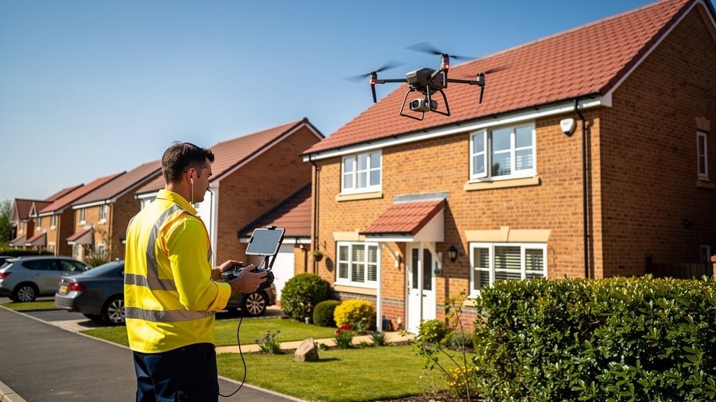
Understanding Modern Drone Roof Survey Technology
Today's professional roof survey drones bear little resemblance to consumer hobby drones. These are sophisticated aerial platforms equipped with specialized cameras and sensors designed specifically for building inspection work.
Professional Survey Drone Capabilities:
- High-resolution cameras: 20+ megapixel sensors capturing minute detail visible in images
- 4K and higher video: Ultra-high-definition video footage documenting entire roof condition
- Zoom capabilities: Optical and digital zoom allowing close inspection without proximity
- Thermal imaging: Infrared cameras detecting temperature anomalies indicating moisture problems
- GPS positioning: Precise location data for every photograph taken
- Obstacle avoidance: Sensors preventing collision with buildings, trees, or power lines
- Stability systems: Gimbal stabilization ensuring sharp images even in moderate wind
These advanced systems allow professional surveyors to capture comprehensive roof documentation without ever leaving the ground, examining areas that would be dangerous or impossible to access via traditional methods.
The Drone Survey Process: What to Expect
Professional drone roof surveys follow a systematic approach ensuring comprehensive coverage and regulatory compliance.
Pre-Survey Planning and Risk Assessment
Before any drone takes flight, surveyors conduct thorough planning:
- Airspace checks: Verifying property location relative to airports, restricted zones, and local flight restrictions
- Weather assessment: Ensuring wind speeds, precipitation, and visibility meet safe operating parameters
- Site risk evaluation: Identifying power lines, trees, and other obstacles requiring navigation caution
- Neighbor notification: Informing adjacent properties when required by local privacy considerations
- Flight path planning: Determining optimal angles and altitudes for comprehensive roof coverage
My Roof Surveyor UK holds full CAA (Civil Aviation Authority) commercial drone operator certifications, comprehensive insurance, and follows strict safety protocols for every survey.
The Inspection Flight
During the actual survey, trained pilots systematically photograph and video the entire roof structure:
Typical inspection sequence:
- Perimeter orbit: Flying around property to document overall roof condition from all angles
- Vertical ascent: Rising to capture overhead views showing complete roof layout
- Detailed passes: Close approaches to specific areas documenting tile condition, flashing, ridges, valleys
- Focus areas: Zoomed photography of any defects or problem areas identified
- Contextual imaging: Wider shots showing roof in context of property and surroundings
A typical residential property survey takes 15-30 minutes of flight time, compared to 2-3 hours for traditional surveys involving roof access, ladder positioning, and safety setup.
Post-Flight Analysis and Reporting
After the flight, surveyors analyze hundreds of high-resolution images and video footage:
- Reviewing imagery systematically for defects and problems
- Zooming into specific areas for detailed examination
- Creating annotated images highlighting defects
- Comparing multiple angles of problem areas
- Measuring damage extent using scale references
- Preparing comprehensive written reports with photographic evidence
The combination of aerial perspectives and zoom capabilities often reveals problems that would be missed during traditional surveys—tiles lifted at edges, moss buildup in hidden valleys, flashing gaps invisible from ladder access points.
Key Advantages of Drone Roof Surveys
Drone technology delivers multiple benefits over traditional ladder-and-foot-access survey methods.
1. Enhanced Safety
Working at height remains one of the UK's most dangerous activities. Health and Safety Executive statistics consistently show falls from height as a leading cause of workplace fatalities and serious injuries.
Safety benefits of drone surveys:
- Eliminates surveyor risk of falls from ladders or roofs
- Removes need for scaffolding on multi-story buildings
- Prevents accidental damage to fragile roof coverings from foot traffic
- Enables inspection of dangerous or unstable roofs without access
- Protects surveyors from asbestos, biological hazards, or deteriorated structures
A Manchester commercial property we surveyed had a large flat roof suspected of having structural issues. Traditional inspection would have required surveyors to carefully walk the surface while assessing safety. Our drone survey revealed that approximately 40% of the deck had deflected significantly—walking on it would have been genuinely dangerous. The drone survey identified the problem without putting anyone at risk.
2. Superior Coverage and Detail
Drones access views and angles impossible for surveyors on foot:
- Complete roof coverage: Every square meter examined systematically
- Inaccessible areas: Steep pitches, high elevations, and dangerous sections safely inspected
- Multiple perspectives: Same area documented from various angles revealing different problem aspects
- Hidden valleys and gutters: Internal roof areas typically invisible to ground observers
- High-level details: Ridge tiles, chimney conditions, and apex details clearly visible
Traditional surveys often miss problems in areas surveyors can't safely access. Drones eliminate these blind spots.
3. Time and Cost Efficiency
Drone surveys significantly reduce inspection time and associated costs:
Time savings:
- No scaffolding erection or removal (saving days or weeks)
- No ladder positioning and repositioning around property
- Rapid deployment—ready to survey within minutes of arrival
- Multiple properties can be surveyed in single days
Cost benefits:
- Lower labor hours required for survey completion
- No scaffolding hire costs (£500-£2,000+ for complex properties)
- No cherry picker or elevated platform rental
- Reduced property owner disruption and inconvenience
A Leeds property portfolio manager required surveys of twenty terraced properties. Traditional surveys would have required two weeks and extensive ladder setup. Drone surveys completed all twenty properties in three days at approximately 40% of the traditional survey cost.
4. Comprehensive Documentation
Drone surveys create permanent, detailed visual records:
- Hundreds of high-resolution images: Comprehensive photographic documentation
- 4K video footage: Complete roof condition recorded in ultra-high definition
- Before-and-after comparisons: Baseline surveys enabling future condition monitoring
- Insurance evidence: Indisputable photographic proof for claims
- Repair verification: Documenting contractor work quality
This extensive documentation provides value beyond the initial survey—property owners have permanent records for insurance, property sales, or future maintenance planning.
5. Reduced Property Disruption
Drone surveys minimize impact on property occupants:
- No scaffolding blocking windows or building access for weeks
- No ladders positioned against walls requiring garden clearance
- Quick completion allowing normal property use throughout
- Minimal noise compared to scaffolding erection
- No interior access required (unlike loft inspections)
For businesses, this reduced disruption means no lost trading time from scaffolding installations. For homeowners, it means no extended inconvenience or security concerns from access equipment.
When Drone Surveys Excel: Ideal Applications
While drone surveys benefit virtually all roof inspections, certain scenarios particularly showcase their advantages.
Large Commercial and Industrial Properties
Warehouses, factories, shopping centers, and office buildings with extensive flat or low-pitch roofs:
- Traditional surveys of large commercial roofs can take days
- Drone surveys complete in hours with superior coverage
- Thermal imaging identifies moisture problems across vast roof areas
- No disruption to business operations below
- Regular condition monitoring becomes economically viable
We surveyed a Birmingham distribution warehouse with 15,000 m² of flat roofing. Traditional survey would have required several days of walking the surface. Our thermal-equipped drone completed comprehensive inspection in four hours, identifying three distinct areas of moisture ingress requiring targeted repairs rather than wholesale roof replacement—saving the client approximately £180,000.
High-Rise and Multi-Story Buildings
Properties where height makes traditional access dangerous and expensive:
- No scaffolding required (typical cost £5,000-£20,000 for high buildings)
- No cherry picker rental and operator costs
- Complete inspection including chimneys, parapets, and high-level details
- Safe assessment of dangerous or deteriorated high-level elements
Period and Heritage Properties
Historic buildings where roof access risks damaging fragile materials:
- No foot traffic on delicate old tiles or slates
- No ladder damage to historic masonry or render
- Detailed documentation of decorative roof features and ornamental details
- Assessment of hard-to-reach architectural elements
A Grade II listed Georgian townhouse in Bath required roof survey before restoration works. The 200-year-old handmade clay tiles were fragile and irreplaceable. Drone survey provided comprehensive assessment without risking damage to historic materials—documenting conditions in extraordinary detail for conservation architects.
Post-Storm Damage Assessment
After severe weather, rapid comprehensive assessment is crucial:
- Quick deployment without waiting for scaffolding
- Safe inspection of potentially compromised structures
- Complete damage documentation for insurance claims
- Identification of emergency repair priorities
Pre-Purchase Property Surveys
Buyers benefit from drone surveys' comprehensive coverage:
- Complete roof condition assessment before purchase commitment
- Identification of hidden problems reducing negotiating position
- Visual evidence that non-specialist buyers can understand
- Comparison of multiple properties under consideration
Limitations and When Traditional Methods Are Still Needed
While drone technology has revolutionized roof surveying, it doesn't replace all traditional methods entirely.
When Drones Can't Provide Complete Assessment:
- Interior roof structure: Drones can't access loft spaces to examine rafters, insulation, or interior moisture
- Detailed material assessment: Physical examination of tile condition, mortar hardness, or batten integrity requires hands-on inspection
- Core sampling: Determining flat roof construction layers requires physical samples
- Penetrating damp meters: Measuring moisture content in specific materials requires contact
- Testing mechanisms: Checking gutter fixings, testing drainage, or verifying flashing flexibility needs physical interaction
My Roof Surveyor UK typically recommends combined approaches for comprehensive surveys—drone inspection for complete external assessment plus targeted traditional access for specific areas requiring hands-on examination or testing.
Regulatory Framework and Professional Standards
Professional drone roof surveys operate within strict regulatory framework ensuring safety and competence.
UK Drone Regulations for Commercial Surveys:
- CAA Permission: Commercial drone operators must hold Civil Aviation Authority commercial certification
- Pilot qualifications: Operators must pass theory exams and practical flight assessments
- Insurance requirements: Minimum £1 million public liability (most professionals carry £5-10 million)
- Flight restrictions: Compliance with airspace restrictions, altitude limits, and visual line-of-sight rules
- Privacy considerations: Adherence to data protection and privacy regulations when capturing images
Property owners should verify:
- Survey company holds valid CAA commercial drone permissions
- Pilots are trained and certified
- Comprehensive insurance covers drone operations
- Company follows proper risk assessment and flight planning procedures
The Future: Emerging Drone Survey Technologies
Drone surveying continues to evolve with new capabilities enhancing roof assessment quality.
Emerging Technologies:
- AI-powered defect detection: Artificial intelligence systems automatically identifying problems in drone imagery
- 3D modeling: Photogrammetry creating accurate 3D roof models from drone photographs
- LiDAR integration: Laser scanning for precise dimensional measurements and deflection detection
- Multi-spectral imaging: Advanced sensors detecting vegetation stress, moisture, and material degradation
- Automated flight paths: Programmed inspection routes ensuring consistent, repeatable surveys
These advancing capabilities will make drone surveys even more comprehensive, identifying problems that currently require experienced surveyor interpretation.
Key Takeaways
- Drone technology provides safer roof surveys by eliminating work at height risks
- Superior coverage includes areas impossible for traditional surveyors to access safely
- Time and cost savings are significant, especially for large or high-rise properties
- Comprehensive photographic documentation creates permanent condition records
- Thermal imaging drones detect hidden moisture problems
- Combined drone and traditional approaches deliver most comprehensive surveys
- Ensure survey companies hold proper CAA certifications and insurance
Frequently Asked Questions
For external roof assessment, drone surveys often exceed traditional survey thoroughness because they access views and angles impossible for surveyors on foot. High-resolution cameras capture minute detail that can be examined closely during post-flight analysis. However, comprehensive surveys may combine drone inspection with targeted traditional access for interior loft inspection or physical testing of specific materials. This combined approach delivers the most complete assessment.
Residential drone surveys typically cost £400-£700 depending on property size and complexity. Commercial property surveys range from £600-£2,000+ based on roof area and requirements. While this might seem expensive, drone surveys eliminate scaffolding costs (£500-£2,000+) and are significantly cheaper than traditional surveys requiring extensive access equipment for large or high-rise buildings.
Professional drone operations cease when wind speeds exceed safe limits (typically 25mph for survey work), during rainfall, or when visibility is poor. Cold temperatures reduce battery performance and may limit flight duration. Responsible survey companies will reschedule rather than compromise safety or survey quality. Ideal conditions are dry, calm days with good visibility—most achievable year-round in the UK with flexible scheduling.
Thermal imaging is highly effective for detecting moisture in roof structures, particularly flat roofs where wet insulation shows clear temperature differences. However, optimal results require appropriate conditions—typically evening or early morning when temperature differentials are greatest. Thermal imaging detects moisture but can't always identify the exact leak source without additional investigation. It's one component of comprehensive survey approach, exceptionally valuable for flat roofs and identifying hidden problems.
Property owner presence isn't usually required during the survey itself, though some owners enjoy watching the process. However, arranging access to property grounds and discussing any specific concerns beforehand is valuable. Many clients prefer to be present for the post-survey discussion when surveyors explain findings. The flexibility of drone surveys means scheduling can accommodate your availability without the extended time commitment traditional surveys require.
Experience Professional Drone Roof Surveys
My Roof Surveyor UK employs CAA-certified drone pilots with specialist roof surveying expertise. Our professional-grade drones equipped with high-resolution cameras and thermal imaging sensors provide comprehensive roof assessments with unprecedented detail and safety.
Whether you're managing commercial property portfolios, considering property purchase, or concerned about your home's roof condition, our drone survey services deliver thorough, cost-effective assessments with comprehensive photographic documentation.